Exhibits
Drawing upon its voluminous collection of photographs, books, and paper records the Missouri State Archives creates colorful exhibits that tell the stories of Missouri's exciting past. The Archives shares these stories with the people of Missouri through on-line exhibits and by making exhibits available to local museums, libraries, historical societies, and educational institutions to borrow free of charge. Ideal for venues with small budgets and staff, each exhibit is easy to install and requires a minimum of security. For more information about Missouri State Archives traveling exhibits, contact [email protected] or call 573-526-5296.
Traveling Exhibits
Pillars of the State: the Centennial of the Missouri State Capitol, 1907-2017
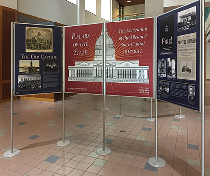
On the evening of Sunday, February 5, 1911, lightning struck the dome of the Missouri State Capitol, igniting a fire that completely destroyed the building. Construction began on the new capitol building on May 6, 1913. More than eleven years later, in October 1924, tens of thousands of people flocked to the new capitol's dedication ceremony, which included a parade, band concert, speeches by government officials and a historical pageant.
Pillars of the State uses drawings, maps, photographs and documents to tell the story of each of these landmark events and more. The exhibit includes more than two dozen of the photographs Thomas Garfield Cooper took to document the process of transforming the capitol grounds and building the statehouse and the nearby powerhouse. The exhibit also features beautiful twenty-first century color photographs of the capitol interior and artwork, taken by Jefferson City photographer Lloyd Grotjan.
Blueprints for Democracy: Public Architecture in Missouri
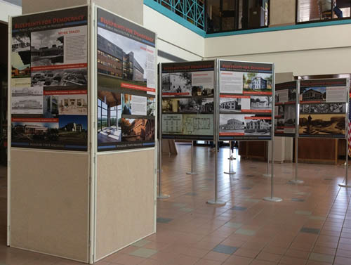
When Missouri entered the Union on August 10, 1821, the permanent capitol in “The City of Jefferson” was still years from completion and the state legislature needed a temporary place to meet. The city of St. Charles lured the legislature with the promise of free meeting space. For five years, government officials conducted the state’s business on the second floor of two adjoining buildings – one a general store and the other a carpentry shop.
Now, nearly two centuries later, the State of Missouri owns hundreds of buildings in dozens of cities and towns across the state. Hospitals, classrooms, office buildings, prisons, maintenance garages and more, all play an important role in state business. County and municipal buildings likewise, have become important parts of the built environment.
Blueprints for Democracy surveys the rich history of publicly funded architecture in Missouri. From Fort Osage, which was once the U.S. military’s most westerly outpost, to the Gateway Arch, which pushed the boundaries of design and engineering, many of the state’s most significant architectural achievements have been built with public funds. Because of this, these structures often reflect our attitudes about the public good and fiscal accountability. Just as often, however, public buildings express our common dreams and aspirations. Older buildings document the ideals of past generation and help us better understand our artistic and cultural heritage.
Always functional and often aesthetically pleasing, publicly funded buildings help tell the story of state and local history.
A Legacy of Conservation:
The 75th Anniversary of the Missouri Department of Conservation
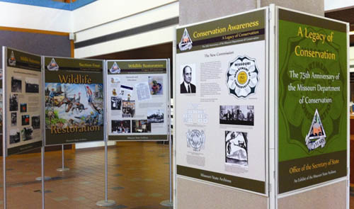
A Legacy of Conservation offers a look back at the rich 75-year history of conservation in Missouri. The Missouri State Archives draws on its collection of more than 160 cubic feet of Conservation Commission photographs, documents and publications, as well as materials provided by the Conservation Federation of Missouri, to present this exhibit.
Divided Loyalties:
Civil War Documents from the Missouri State Archives
An exhibit of the Missouri State Archives
 Divided Loyalties: Civil War Documents from the Missouri State Archives examines the upheaval and uncertainty that characterized Missouri during the Civil War era. Drawing on more than nine million pages of Civil War-related documents and court cases, the exhibit goes beyond the stories of battles and military strategy to consider the charged atmosphere of social conflict that permeated the state for the two decades that followed the Kansas Border Wars of the mid-1850s. Through state documents, maps, images and court cases, Divided Loyalties shows that the Civil War in Missouri was not fought solely on the battlefield. The conflicts that surrounded the war were so divisive that they affected civilian and soldier alike.
Ozark Light
The Photographs of Charles Elliott Gill
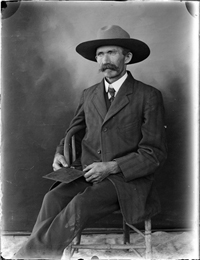
Self Portrait, Charles Elliott Gill
Charles Elliott Gill spent the early decades of the 20th century documenting the world around him with his 1906 Seroco extended view camera. Gill was one of a new generation of amateur photographers who was able to move out of the studio and into the landscape thanks to the advent of portable cameras and manufactured glass plate negatives. He utilized the freedom brought about by new technology to photograph the places, people and events that he encountered both on his travels across the continent and near his home in Dent County, Missouri.
A farmer by trade, Gill never received formal training as a photographer. Nonetheless, his images reveal he was influenced by the fine art photographers of his era and that he possessed a keen eye for detail, a flair for classical composition, and a wry sense of humor. Ozark Light features more than 100 photographs from the Missouri State Archives’ extensive collection of work by this self-taught master of black and white photography.
View the digital image collection.